Another La Niña season ahead
Maybe you’ve heard the rumours about another wet and cold summer in Australia. Yes, the rumours are true, we have another La Nina season ahead.
The Bureau of Meteorology is warning for another wet summer for the eastern coast of Australia. We will experience a third La Niña season in a row.
So, what is La Niña, and El Niño? We better start with the covering the basics.
La Niña and El Niño are particular phases of the ENSO climate cycle.
Oh, hold on? What is the ENSO climate cycle?
The ENSO is the natural cycle of the temperatures, trade winds and clouds in the Pacific Ocean region. It’s one of Australia strongest climate drivers, meaning that these patterns influence our weather. There are 3 key phases in the ENSO cycle, neutral, La Niña & El Niño.
During the neutral phase, trade winds from the eastern pacific region blow across the tropical pacific from east to west. These winds pile up warm water in the western region which creates a process that pushes cold waters up to the surface in the east. The same process causing warmer temperatures to rise in the west and descending in the east, creating a huge cycle called the ‘Walker circulation’.
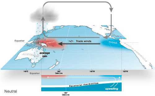
The neutral phase of ENSO Source: http://www.bom.gov.au/climate/enso/history/ln-2010-12/three-phases-of-ENSO.shtml
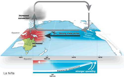
The La Nina phase of ENSO Source: http://www.bom.gov.au/climate/enso/history/ln-2010-12/three-phases-of-ENSO.shtml
The neutral “normal” phase is the dominating phase and this is what we experience more than half of the time.
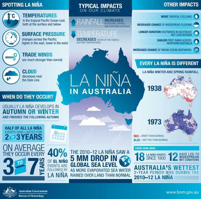
Influences of La Nina in Australia. Source: http://www.bom.gov.au/climate/enso/images/La-Nina-in-Australia.pdf
La Niña is explained as the “cold phase” of the ENSO climate cycle. The trade winds blow more intense, which makes the Walker circulation stronger and in turn respond to the processes by creating a feedback loop. The enhanced trade winds are pushing the colder temperatures further west and cooling a greater part of the tropical pacific region. This process also helps to pile up warm surface waters in the western Pacific and to the north of Australia.
With higher ocean temperatures in the west, we experience an increase in evaporation which generate more clouds and a significant increase in rainfall.
Although, weather patterns are highly variable, and it’s difficult to predict what the conditions will be this season. We cannot fully predict what the weather, and especially on a local level.
So, what are the potential impacts on the Reef for another La Niña ahead?
- The cooler condition typically brings more clouds and rainfall. The clouds act as a shade and protects the corals from sun exposure and intense UV rays. In combination with cooler ocean temperatures, the conditions could reduce the Reef from heat stress and lessen the chance of bleaching events.
What we need to look out for…
- Severe weather events.
La Niña typically brings more cyclones in the northern eastern part of Australia. The damages on the Reef followed by a cyclone event could be significant and turn large areas into rubble.
- Flooding events.
The weather conditions on land can unfortunately have a negative impact the Reef. Flooding events typically brings an overload of pollutants from the water ways straight into the ocean bringing sediments, nutrients and pesticides which affects the water quality.
Coral reefs provides important ecosystem services (read more here) and it’s so important that we’re on the alert how it’s affected by external factors. In that way, we can determine what measures we can undertake to protect what we love the most.


Photo Cred: Natalie Lobartolo